Lidar is a kind of active detection technology that can obtain the information of the ground or the atmosphere in three dimensions accurately and rapidly. The application range and development prospect are very broad. In the past, the sensor can only obtain the spatial plane information of the target, and the three-dimensional elevation information needs to be acquired through the technology of homochronous and heterogenous overlap imaging. Compared with LiDAR technology, these methods not only have low ranging accuracy and data processing is also complicated. Because of this, LiDAR technology, together with imaging spectroscopy and synthetic aperture radar, is cited as the core information acquisition and processing technology in Earth Observation System programs. Lidar is the laser technology, high-speed information processing technology, computer technology and other high-tech products.

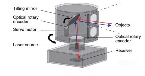
Lidar is a radar system, is an active sensor, the data formed is a point cloud form. The work of the spectral band in the infrared to ultraviolet, the main transmitter, receiver, measurement control and power components. The working principle is as follows: Firstly, a high power laser beam is emitted to the measured target, and then the time when the reflected or scattered signal reaches the transmitter, the signal intensity and the frequency change are determined to determine the distance, the moving speed and the orientation of the measured target. In addition, you can measure the atmospheric particles can not see the dynamic situation. Lidar’s function is to accurately measure the target’s position (distance and angle), shape (size) and state (speed, attitude), so as to achieve the purpose of detecting, identifying and tracking the target.
Status and Application of Lidar
Military applications
At present, great achievements have been made in such fields as mine detection laser radar, chemical reagent detection laser radar, atmospheric monitoring laser radar, and biochemical land-based laser radar. In addition, China’s attack laser radar has been quite advanced, including the world’s most advanced five core technologies: the breakthrough of laser material research, the physical mechanism of laser radiation materials and imaging research breakthrough, a one-time rapid tracking positioning control technology breakthrough, High-density energy reversible conversion of carrier materials breakthrough, a breakthrough laser imaging technology.
Wind measurement applications
Doppler wind lidar with high resolution, high precision, large detection range, can provide clear wind conditions under the conditions of three-dimensional wind information capabilities. The Doppler wind lidar uses the Doppler effect of light to measure the Doppler shift of the blue laser pointer beam transmitted in the atmosphere and its echo signal to retrieve the space wind velocity distribution. There are mainly coherent (heterodyne) detection and non-coherent (direct) detection of two ways.
Meteorological applications
China has set up 12 long-term observation stations for dust storms, and for the first time formed a nationwide sandstorm monitoring network. Through advanced observations, simulations and satellite remote sensing joint research to identify the exact source of dust storms in China, the scientific identification of natural factors such as meteorological and climatic conditions and desertification land increased human factors such as sandstorms, accurate warning , Forecast dust storms, to develop a comprehensive and efficient prevention and treatment plan to provide a scientific basis.
Medical applications
Oak Ridge National Laboratory, part of the U.S. Department of Energy, has developed a system that integrates laser and radar systems that reduce the pain of burns. Researchers hope this co-frequency CW laser radar mapping system will remove necrotic skin and muscle from the patient’s body. This new system enables 3D laser lidar localization of burned patients’ surface tissues to determine the degree of damage. Using probe positioning results, the green laser pointer can automatically remove necrotic tissue to facilitate new tissue growth.
Application of soil and water conservation monitoring
At present, due to the influence of construction and development in the whole country, great difficulty has been brought to the governance of soil and water loss. According to the survey, the area of soil erosion reaches 1.00 × 10⁴ square kilometers per year due to development and construction throughout the country. Lidar is more accurate and reliable than the traditional method in terms of measurement accuracy. It can reflect the shape of the field in detail and easily realize the three-dimensional modeling so that the non-contact measurement can be greatly reduced The workload of the field is reduced, the risk of the field is reduced; and many forms of soil and water loss such as excavation slope, collapse hill and landslide can be measured, and the traditional soil and water conservation can be embarked on the road of “intensive farming”.
The development trend of laser radar
Satellite Lidar
The satellite-borne LiDAR uses satellite as a platform and has high orbits, wide observation range, fast observation speed, small influence on the background of the sky and sky background, high resolution and high sensitivity, and can reach almost every corner of the world. Three-dimensional control points and digital terrain model (DEM) access to provide a new avenues, in defense or scientific research and other fields have a very significant value and research significance. The onboard LiDAR also has the ability to observe the entire celestial body and achieve astrometric mapping, global information collection, global environmental monitoring, investigation of agricultural forestry resources, and measurement of atmospheric structural components. In addition, the on-board LiDAR can also play an important role in vertical distribution of vegetation, sea level measurement, vertical distribution of clouds and aerosols, and monitoring of special climate phenomena. At present, the internationally developed spaceborne lidar has: the NASA / LaRC spaceborne differential radar in the United States, the Moon Observing Clementine system, the Mars Explorer’s MOLA-2 system, the NRL system for observing space asteroids, the GLAS system for Earth Observation , Backscatter radar ATLID. Researching and solving the key technologies of on-board Li-DAR and establishing our own on-board LiDAR system will be an important development direction of our country’s Lidar.
Battlefield reconnaissance laser radar
Lidar may become an important reconnaissance tool and means. The company is experimenting with the manufacture of the ILR100 imaging lidar using GaAA red laser pointer line scan sensors, which can be installed on commercial aircraft and unmanned aerial vehicles to perform reconnaissance missions at altitudes of 120-460 meters. The reconnaissance images may be transmitted in real time to a cathode ray tube display on the aircraft or directly to a ground receiving station over a data link.
Wind laser radar
Measuring wind speed is very important for studying climate change, improving the accuracy of weather forecasting, monitoring airport air flow, optimizing aircraft routes and in military and rocket launching. At present, about 2μm all-solid-state coherent laser radar and the incoherent laser radar transmitting in the ultraviolet region will be the focus of future development.
Lidar seekers
LIDAR can provide distance and intensity-based high-resolution images that enable space weapons to be autonomous and accurately guided. Lidar seekers form a three-dimensional image of the target, ensuring accurate recognition of the target. At present, the United States Air Force Wright Laboratory and the Navy jointly launched a demonstration project based on solid-state lidar, the purpose is to complete the laser radar seeker and autonomous capture target. The LIDAR seeker will be installed on the AGM-130, a joint ground-to-ground long-range missile to enhance autonomous guidance and combat accuracy.
As the laser radar is a cost, good effect, the use of a wide range of remote sensing means, I believe the future will be more widely used.